Active Weather Day; Another Tornado Outbreak Likely
SEVERE WEATHER OUTBREAK TODAY: Here we go again, as another very dangerous threat for severe weather is ahead for Alabama today. The SPC has issues the rare “high Risk” (level 5/5) for that parts of Mississippi and Alabama. The “moderate risk” (level 4/5) is defined north and west of a line from Linden to Marion to Calera to Talladega. An “enhanced risk” (level 3/5) runs as far south and east as Jackson, Camden, Prattville, and Alexander City…the “slight risk” (level 2/5) extends to Opelika, Troy, and Andalusia. A “marginal risk” (level 1/5) has been defined for the southeast portions of the state.

Here is the outlook for the counties serviced by the NWS Office in Birmingham, which includes our West, Central, East, and Southeast counties…

And here is the outlook for the counties serviced by the NWS Office in Mobile, which includes our Southwest and South Alabama counties…

Again, don’t focus on the lines or colors on the maps, just know, that all of Alabama is under the threat for severe storms from this event. It doesn’t matter to the storms, they can produce a tornado in a “marginal risk” area just like they can in a “high risk” area.
THE SETUP: This is another, typical spring-time severe weather set-up for Alabama as a potent, negatively tilted upper air trough is generating a deepening surface low west of Alabama. This is causing a warm front to lift north, allowing for surging instability values today, and the deepening surface low northwest of the state, will allow for strong wind fields aloft, high shear values, and steep lapse rates, providing an environment favorable for severe thunderstorms for Alabama and the Deep South.
THREATS: All types of severe weather will be possible as thunderstorms will be capable of producing large hail, damaging winds, and tornadoes. Some violent, long track tornadoes are possible, in the “high” and “moderate risk” areas, especially along and north of I-59, but again, all of Alabama is under the threat for severe storms during this event.
TIMING: The warm front lifting north this morning is producing, showers and storms, and some these are strong and locally severe. Sometimes as a warm front lifts north ahead of a dynamic system, they can produce some stronger storms, which can produce large hail and the chance for tornadoes due to the change in wind direction across the boundary. Just something to watch through the morning hours until it lifts north of the area. Now for the main event, the window for severe thunderstorms over Northwest Alabama will run from noon until 9 pm. For places like Birmingham, Tuscaloosa, Anniston, and Gadsden the window is from 3pm until 11 pm, and for Montgomery and points south and east the threat will come from 5pm until midnight.
FLOODING: With recent rain and more expected, there could be some issues with flooding and flash flooding. The heaviest rain with this event will come over the Tennessee Valley of North Alabama, where some places could see 2-4 inches of rain, for the rest of the state, amounts will be in the 1-2 inch range.
CALL TO ACTION: We all did an incredible job of being ready for last week’s severe weather event on March 17th. We had 27 tornadoes in the state and despite the major damage, there was not a single fatality. We need to have the same level of preparedness for tomorrow.
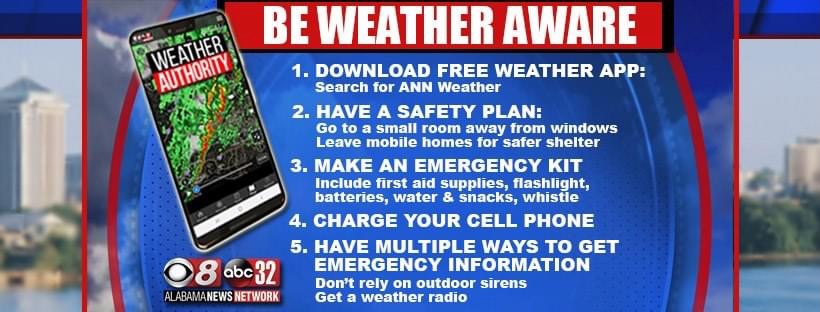
Have multiple, reliable ways to receive severe weather alerts, NEVER, ever, ever rely on a siren. Every Alabama home and business needs a NOAA Weather Radio (the most popular model is the Midland WR-120, which is sold in most local big box retailers). The other way is your phone… be sure emergency alerts are enabled (look under settings, and notifications), and install the free Alabama News Network Weather app.

Know the safe place in your house, and in that safe place have helmets for everyone. Bicycle helmets and batting helmets work well. We also recommend portable air horns and hard soled shoes for everyone. If you live in an apartment complex, you can’t be above the first level. Shelter with a friend on the ground level, or ask management if they can open the clubhouse during a tornado warning.
If you live in a mobile home, you can not stay there during a tornado warning, they offer little to know protection from severe storms. Know the location of the nearest shelter, or business that is open 24/7. Know how to get there quickly.
BE A HERO: You can help us. Tell your friends, neighbors, and relatives about the threat, and what they need to do to get ready. And, if they fall in a tornado warning polygon, call them or text them to let them know about the threat. You are our most valuable resource in spreading the word!
Many of you have anxiety about severe weather, especially those that have gone through tornadoes or other kinds of violent weather. Have comfort knowing that even on the biggest severe weather days, odds of any one home being hit by a tornado are very low. But, you have to pay attention and be prepared. We will get through the day together.
FRIDAY: Calm weather arrives tomorrow as the front pushes down into South Alabama and stalls, and the sky becomes partly sunny with a high in the 70s for the northern half of the state. By Friday night, the front lifts back north as a warm front and will help produce showers and storms, and some of these could produce gusty winds and small hail.
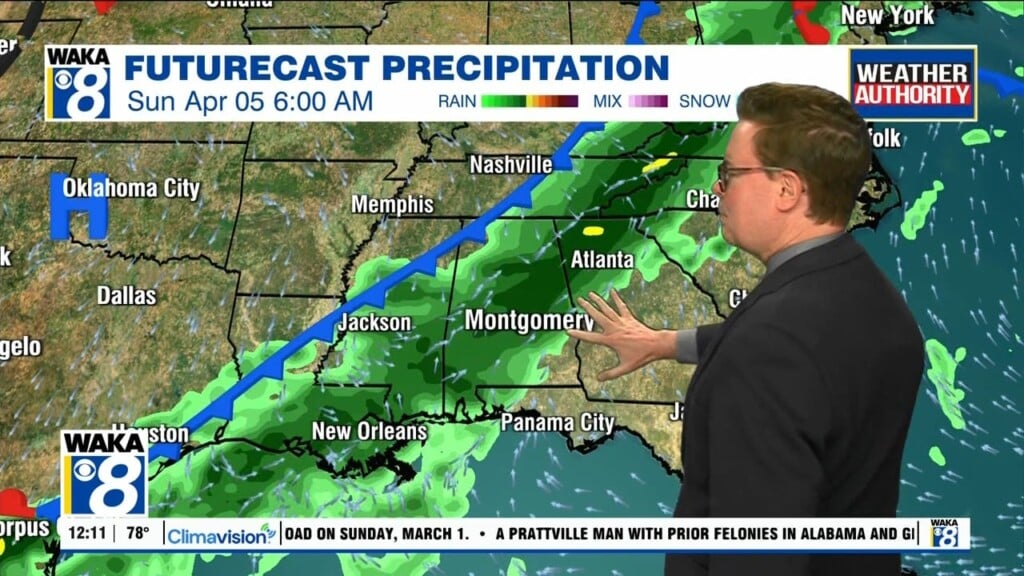
WEEKEND WEATHER: For the weekend, the warm front will be over North Alabama, so clouds and areas of rain will remain possible Saturday for the northern half of the state, while the southern half of the state looks mainly dry. It will be warm with highs likely surging into the mid 80s. On Sunday, the front pushes back to the south so rain and storms will impact much of Central and South Alabama. Highs Sunday will be in the 70s.
Stay weather aware!!!
Ryan