Warm Thursday; Winter Weather Issues Not Far Away
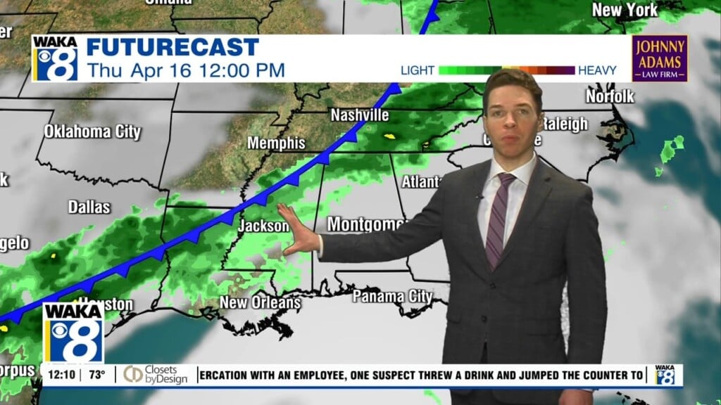
RAIN ON THE WAY: Rain becomes widespread across Alabama today ahead of the Arctic cold front just north of the state. As the front slowly sinks south, we are going to see rain and storms at times today and tonight and warm temperatures in the 70s. There will be some surface based instability, which will allow for storms, and perhaps a few stronger storms, but with the better shear values north of the front, severe storms are not in the forecast. Rain amounts around one inch are expected through tomorrow. Tomorrow will continue to be wet at times and it will be a cooler day with highs in the 50s.
WINTER ISSUES ACROSS THE U.S.: Arctic air with frigid temperatures and dangerous wind chills continue to blanket the Central third of the U.S., while beginning to expand into the Northwest. Two large winter storms are taking shape with an ice storm from Arkansas to Kentucky and snow for the Mid-Atlantic through early Friday, while a potent storm moves into the West for heavy snow and wintry precipitation in the Northwest
ICE ISSUES NOT FAR AWAY: An ice storm warning is in effect for parts of Arkansas, West Tennessee, and much of Kentucky as freezing rain is expected to bring a coating of ice that will create major travel impact and possible power outages through tomorrow. Little Rock, Memphis, Bowling Green, and Lexington are expecting issues.
THE ALABAMA WEEKEND: The worst of the bitterly cold Arctic air still looks to hold north and west of Alabama, but the weekend air will be cooler with highs in the 50s both Saturday and Sunday across Central and South Alabama, but locations across North Alabama, may hold in the 30s. We are going to see more rain throughout the weekend as wave after wave of low pressure tracks along the frontal boundary. There could be a brief period of freezing rain for portions of North Alabama, at times as well, but it really looks like most of the state will just deal with a cold rain. We are not expecting any ice issues for Alabama through the weekend, but again, this is a complex and complicated weather pattern and the forecast is always subject to change.
INTO NEXT WEEK: For now, Monday starts off dry, but yet another wave of low pressure looks to bring more widespread precipitation back to the state Monday afternoon, night and into Tuesday. Again, depending on temperature profiles across the state there could be the risk of freezing rain for parts of North Alabama Monday night and into Tuesday, bit for the most part it looks to be mainly cold rain for Alabama. For the rest of next week, expect below-average temperatures with highs in the 40s and 50s most likely, and yet another round of precipitation on Thursday.
Just remember, with so much cold air nearby, and an active southern branch of the jet stream, each feature has to be monitored for the potential winter weather mischief.
May this be your best day of 2021 so far!!!
Ryan