Wet Start to the Work Week
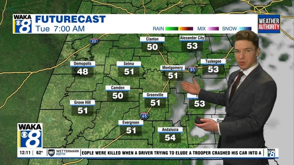
WET START TO THE WEEK: A front is dropping south through the state today and has brought showers and some thunderstorms back to Alabama to start off your Monday, but with conditions becoming more stable and temperatures dropping throughout the day, we’ll lose the thunder aspect to the rain activity. By late afternoon and into the early evening, we get a brief respite from the activity as rain chances drop greatly. Temperatures much of the day will be in the 60s. Tomorrow will be a much cooler day as a widespread soaking rain event will occur with a low tracking along the Gulf Coast. A few rumbles of thunder cannot be ruled out, but severe storms are not a concern as the air will be cool and stale with highs in the 50s.
DRY SECOND HALF OF WEEK: Wednesday will be the start of a dry stretch of days the rest of the work week. Expect the sky to slowly clear Wednesday with highs back in the 60s. Thursday will be a bright and sunny day with mild temperatures, as highs in the upper 60s and lower 70s across the area. A few clouds will move in for Friday, but we’ll stay dry. Highs will be in the upper 60s.
THE CENTRAL ALABAMA WEEKEND: Looks like we’ll finally have a very nice weekend across Central Alabama as we can expect plenty of sunshine with mild temperatures. Saturday’s highs will be in the mid 60s followed by upper 60s for Sunday. Saturday should feature a few more clouds and a rogue shower is possible, but I think most of us stay dry.
Stay dry!!!
Ryan