Very Warm Tuesday; Cold Front on the Way
Today will start off with plenty of sunshine, but clouds will increase by the afternoon, we will remain dry, and it will be another very warm day with highs in the mid to upper 80s. We will be close to the record high of 88° set back in 1972 in Montgomery.
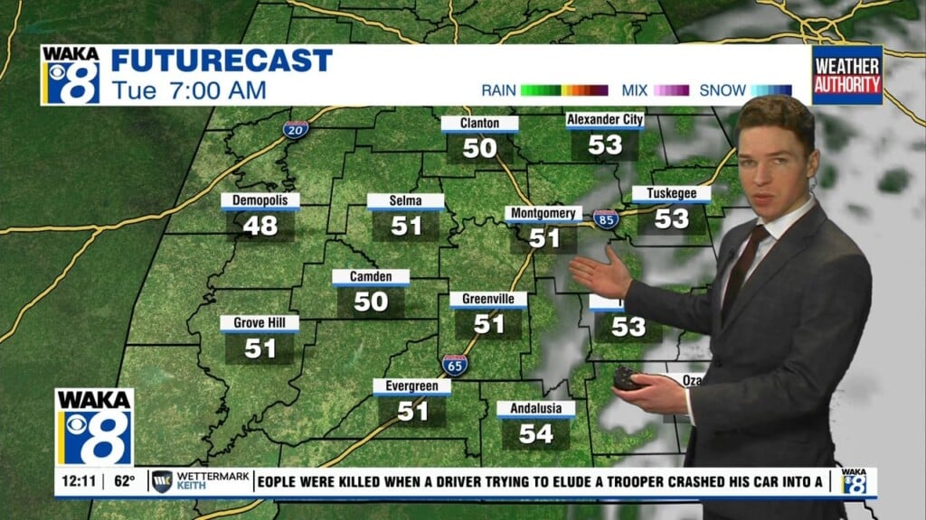
RAIN CHANCES RETURN: A cold front will move approach the area on Wednesday and will bring a chance of showers and a few storms through the day, but thankfully no severe weather. Rain totals should be less than one-half inch, with higher amounts across southern portions of Alabama. Wednesday highs will be in the upper 70s.
COOLER END OF WEEK AND WEEKEND: Showers should continue into Thursday morning, and Thursday and Friday will be cooler days with a mix of sun and clouds both days and highs in lower 70s, which are ten degrees below average for this time of year. Late Friday night, a weak disturbance will bring the higher chances of showers back to Alabama and showers are expected to start our Saturday, but most of the weekend will be dry. The sky will continue to feature more clouds than sun both days with highs in the low 70s both days.
INTO NEXT WEEK: The global models continue to suggest a relatively quiet pattern with little, if any rain through the week along with temperatures at or below seasonal averages. I will certainly take this verses any severe weather threat we frequently can have this time of year. Plus with temps below average, there is no need to start running those air conditioners non-stop just yet.
Be a blessing to someone today!!!
Ryan