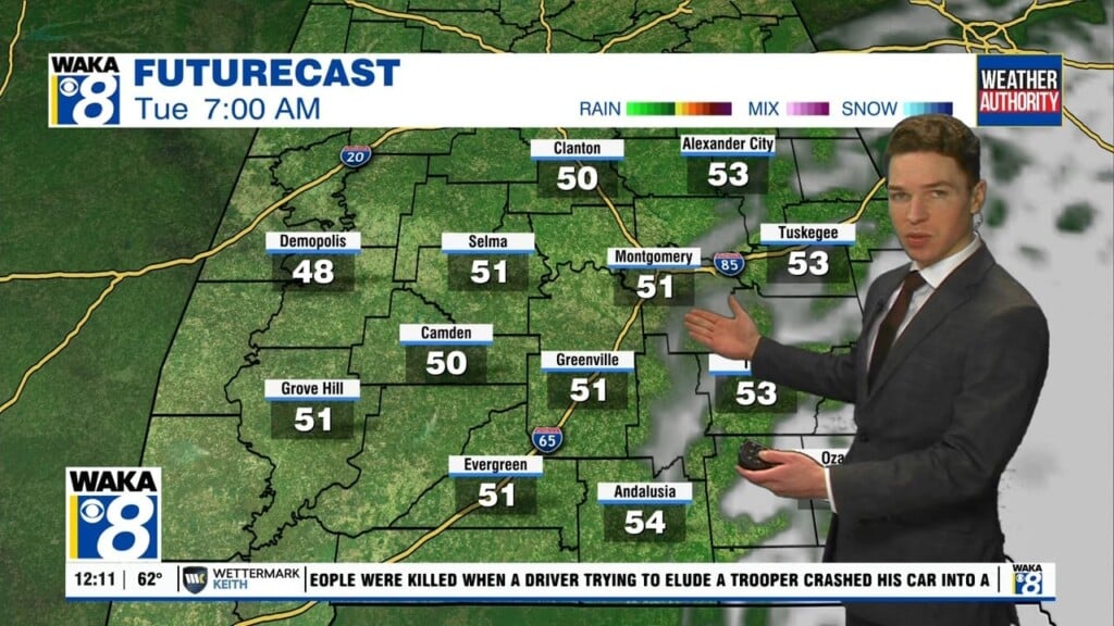
Cooler and Breezy Wednesday
A front is rolling through Alabama this morning, behind the front tomorrow, expect a sunny, beautiful day, but it will be much cooler and breezy, which will make it feel cooler. Highs today will be in the mid and upper 60s. And again, breezy conditions will occur as northwesterly winds gusts 15-25 mph.
COLD NIGHT AHEAD: As the winds go light and with a clear sky, temperatures will have no problem falling to near 40° by tomorrow morning. Most places will stay above freezing with a low in the 35-45 degree range, but colder spots could see some patchy frost, and a frost advisory has been issued for the northern third of Alabama. Tomorrow afternoon will feature tons of sunshine with highs back near 70°.
FOR FRIDAY: For Alabama, Friday will be another dry day with highs in the lower 70s, but clouds will increase through the day as a surface low will be getting its act together off to our west. Friday night the sky will become overcast and some rain is possible after midnight.
RAIN/STORMS RETURN SATURDAY: The dynamic storm system to our west, moves into Alabama on Saturday and will bring widespread rain and thunderstorms to Alabama Saturday. The SPC has defined a risk of severe thunderstorms for about the southern two-thirds of the state, generally along and south of Interstate 20s.

Of course, this area will likely change in the coming days, because the strong/severe threat will only extend as far north as how far inland the warm front makes it. Stronger storms over Alabama Saturday could produce strong winds, and there is some potential for a few tornadoes. All of the state will see a good soaking, with rain amounts of 2-3 inches likely. Some isolated flooding issues could develop during the day; Saturday’s high will be in the low to mid 70s.
GREAT-LOOKING SUNDAY: The rain and storms will end Saturday night as dry air returns to Alabama and Sunday looks like a nice day with a good supply of sunshine, and highs in the 70s.
LEFT TURNS ONLY: It will be a challenge to get in the races Saturday at Talladega; rain and thunderstorms are likely much of the day with a high in the 70s. But, Sunday will be a delightful day for the running of the Geico 500… the sky will be sunny with a high between 73 and 77 degrees.
FINAL WEEK OF APRIL: An upper ridge builds over the region early in the week, which should help temperatures reach the low 80s by Monday and Tuesday. Much of the week looks dry, but a cold front will bring the risk of showers and storms likely on Thursday, strong storms are possible, but too early to know if severe storms will be an issue.
Have an amazing Wednesday!!!
Ryan