Quiet Friday, Stormy Saturday
FINALLY FRIDAY: Today will be another dry day with highs in the mid 70s, but clouds will increase through the day as a surface low will be getting its act together off to our west.
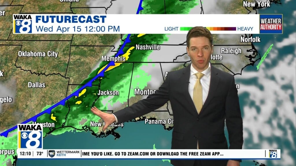
WET & STORMY SATURDAY: A dynamic storm system will approach from the west, and will bring widespread rain and thunderstorms back to Alabama very late tonight and through the day on Saturday. The SPC maintains a “slight risk” (level 2/5) of severe thunderstorms for most Alabama.

It still looks like we will have to deal with two potential rounds of storms…an early Saturday morning round with a northward moving warm front, then a potential round of afternoon storms.
Round one looks to arrive into Alabama around 2AM Saturday and push east through the predawn hours, before exiting the state around 8AM. The round of storms could produce all three types of severe storms including some tornadoes, damaging winds, and large hail. Please make sure you have ways to receive warnings overnight tonight and early tomorrow morning.
Round two is conditional threat, meaning it may or may not happen, and depends on if the atmosphere can destabilize after the morning storms. We will see a lull in the activity through the late morning and midday hours, but as we head into the afternoon, if the air becomes unstable, additional showers and storms will likely form ahead of a cold front. These storms could produce very large hail and strong straight line winds…the wind profiles become somewhere unidirectional by the afternoon, so for now the tornado threat looks low with this round of storms.
CALL TO ACTION: Be prepared and make sure you have all aspects of your severe weather safety plan ready for action. Be sure you have a way of hearing severe weather warnings, and an action plan if you are in a tornado warning polygon, take severe thunderstorm warnings seriously too. Have a NOAA Weather Radio in your home and business,properly programmed with a fresh battery in case of power failure. Be sure WEA (Wireless Emergency Alerts) enabled on your phone… this is not an app, but built into every phone sold in the U.S. Check settings, and notifications, and be sure emergency alerts are on.Have the free Alabama News Network weather app on your phone as a secondary way of getting warnings. Search the App Store for “Alabama News Network” if you don’t have it already.

In a site built home, identify the safe place. Small room, lowest floor, near the center of the house, away from windows. And, in that safe place, have helmets for everyone in the family (including adults!), portable air horns, and hard sole shoes. You CANNOT stay in a mobile home if you are in a tornado warning polygon. Know the closest shelter, and how to get there quickly. Sheltering from a tornado is first priority when it comes to the COVID-19 situation. A tornado is an immediate threat to life; get to your safe place or shelter and do the best you can to protect yourself from exposure to the virus.

For now, we will continue to mention the potential for both rounds of storms. Also, all of the state will see a good soaking, with rain amounts of 2-3 inches likely, and some isolated higher amounts as well. Some flash flooding issues could develop during the day; Saturday’s high will be in the mid to upper 70s.
SUNNY SUNDAY: The rain and storms will end by Saturday night as dry air returns to Alabama and Sunday looks like a nice day with a good supply of sunshine, and highs in the 70s.
RACE WEEKEND: Saturday will feature occasional rain and a few strong thunderstorms at Talladega…the high will be in the low to mid 70s. But, Sunday will be a picture perfect day for the running of the Geico 500 with lots of sun along with a high in the mid 70s.
FINAL WEEK OF APRIL: An upper ridge builds over the region early in the week, which should help temperatures reach the low and mid 80s for Monday, Tuesday, and Wednesday. By Thursday, another dynamic storm system looks to bring rain and perhaps strong storms back to Alabama…stay tuned.
Have a fantastic Friday!!!
Ryan