Rain, storms Thursday through early Friday; Pleasant this weekend
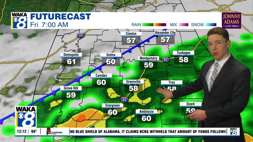
Thursday afternoon remains mainly cloudy with scattered showers. Rain becomes more widespread and heavier with some thunder in the mix Thursday night. Rain totals may range from 1 to 2 inches across our area. The new drought monitor released Thursday shows level 3 to 4 “Severe” to “Extreme” drought across southeast Alabama, so Thursday night’s rain could be very beneficial.
Otherwise, expect temperatures to warm into the low 70s Thursday, and only fall into the mid to upper 50s at most Thursday night. Rain lingers, especially south and east, early Friday, but Friday afternoon looks mainly dry with some sunshine. Temperatures look rather warm, with highs in the low to mid 70s. Friday night could be a bit cooler, with lows in the upper 40s to low 50s. It looks like some fog may develop late Friday night into Saturday morning.
Our weekend weather looks pleasant, with sunshine and dry weather. Temperatures warm into the 70s each day, potentially upper 70s in some locations. Temperatures fall into the upper 40s to low 50s each night. Next week begins dry and warm too, with highs in the upper 70s and a partly cloudy sky Monday and Tuesday. Only minimal chances for rain return for the latter half of the week, while high temperatures remains in the mid to upper 70s.