Storms Are Back in the Forecast
RAIN/STORMS RETURN: The big upper ridge to the south flattens out some, allowing a more zonal pattern across the state, which will allow for weak impulses of energy to move across the state, bringing better rain chances back to Alabama for the rest of this week. For today, expect more clouds with showers and storms moving into the state from the west. We note, the SPC has a low end “marginal risk” (level 1/5) for a small part of West Alabama, where small hail and gusty winds are possible with the storms as they move into the state, around midday, and then push east through the afternoon hours.

There is a not a lot of forcing, so we don’t expect a major severe weather issue. Highs will be a bit cooler tomorrow due to the clouds and rain, expect mid to upper 70s to low 80s.
STORM THREAT WEDNESDAY: Highs return to the mid and upper 80s tomorrow, and with an unstable air mass in place, some more stronger storms are expected across the northern half of the state. For now, the SPC has defined a “slight risk” (level 2/5) of severe storms Wednesday afternoon and evening for the Tennessee Valley of far North Alabama, with a low end “marginal risk” (level 1/5) down into the central part of the state.

Heavier storms could produce gusty winds and hail, but again for now this doesn’t look like a major threat, as there will be no dynamic forcing for severe storms.
END OF WEEK FRONT: More storms are expected on Thursday as a cold front approaches and moves through the state. Again, the main dynamics with this system will be well to the north over the Great Lakes, so for now, we are expecting rain and storms, with a few stronger storms possible, but severe storms are not expected at this time. Behind the front, a late season shot of cooler air arrives in Alabama Thursday night with lows falling into the 40s and 50s. For Friday, the sky becomes partly sunny with much cooler temps as highs in Central Alabama should only be in the upper 60s to low 70s expected.
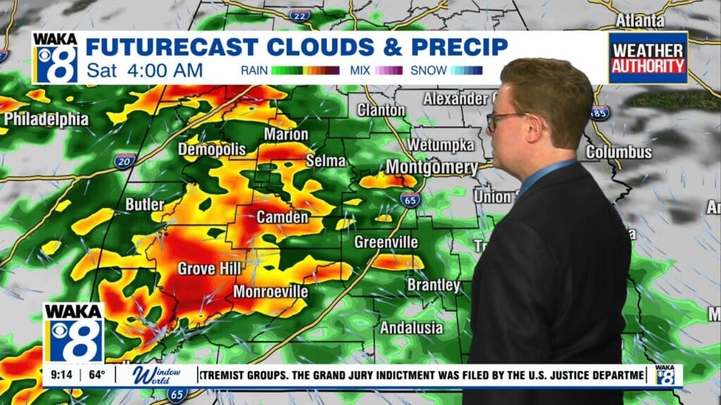
EASTER WEEKEND WEATHER: We are finally starting to get a better understanding of the weather forecast for the weekend. For now, we will forecast a mix of sun and clouds Saturday, with some scattered showers and highs in the 70s. Late Saturday night and into Sunday, a more potent storm system will move across Alabama, and it looks to bring a more widespread rain and storm threat, and it does look like we are going to have the potential for strong to perhaps severe storms. Way too early to know specifics, but just note that Easter Sunday looks to be a stormy one. Behind this system, an area of high pressure will build in across the state, bringing a cooler and drier air mass early next week.
Have a great day social distancing!
Ryan