Record Warmth Today?
PRESIDENTS’ DAY: For today, it will be dry and very nice as a lot of folks will be off work and out of school. Mainly sunny conditions are expected and highs are forecast to be in the upper 70s and lowers 80s for most of South/Central Alabama. The record high for Montgomery today is 80°, set back in 2011. Tonight, clouds begin to increase as the next storm system moves towards the region.
RAIN POSSIBLE: Clouds and the threat of rain returns for Tuesday and Wednesday. We will leave the chance of showers in the forecast for now, but the rain should be more scattered in nature. These two day will be warm with highs likely in the mid 70s. The threat of rain diminishes Wednesday.
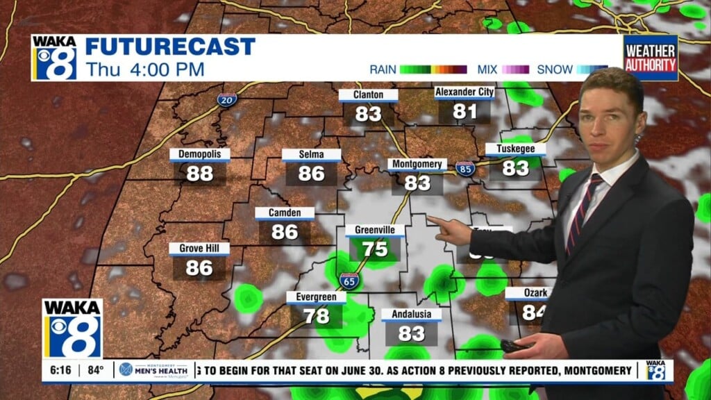
THURSDAY/FRIDAY: We will be in between systems and these two days look dry and very warm now. Highs will once again be near 80° with a mix of sun and clouds both days. On Friday, and trough will cause a low pressure system to track towards the Great Lakes and we are likely to see a cold front move through the Southeast. Moisture return remains questionable and we will add showers and storms in the forecast for now, but severe weather not expected with the main dynamics to the north. Of course things can change and we are going to have to watch this feature all week. The rain with this feature should arrive in Alabama as we head into Friday afternoon and evening.
WEEKEND SNEAK PEEK: Saturday may have lingering showers, but we should see a slightly cooler and drier air mass move into the state thanks to northwesterly flow behind the front. For the most part, next weekend looks cool and dry. Lows look to fall back to the 40s, while highs will be in the uper 60s and 70s.
Have a marvelous Monday!
Ryan