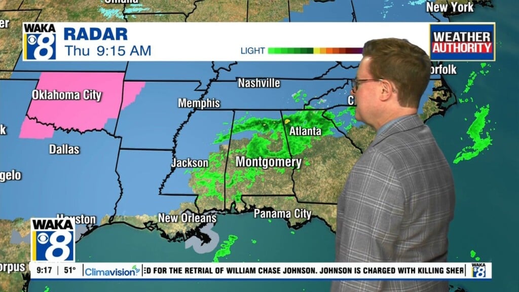
Author: Shane Butler

Sunshine Area Wide Wednesday!

The stubborn clouds will gradually give way to clearing and we’re back into some sunshine Wednesday. We’ll get a couple of days of it and temps will try to warm a bit. Looks like the 60 degree mark is possible Thursday afternoon. Another frontal system will make a push through the area Friday. This could lead to a few showers…

Gradual Clearing Tuesday

The rain is moving out and once the clouds depart, we have some nice weather for a few days this week. The clearing will be gradual Tuesday. This will slow the warming and temps only manage upper 40s to lower 50s for highs Tuesday afternoon. Mostly sunny skies and seasonal temps are in store for Wednesday and Thursday. High pressure…

Some Sunshine Ahead For The Weekend

The clouds will gradually clear out of the area but temps won’t climb much Saturday. We expect a partly sunny sky with temps only managing upper 40s to lower 50s. Skies are clear and temps plunge Saturday night. Sunday morning temps start out in the mid to upper 20s. We reach the low to mid 50s under lots of sunshine…

Clouds Linger Into Friday

An area of low pressure will pass over the deep south tonight and exit to our east Friday. Clouds and possibly a few pockets of light rain will linger over us most of Friday. Temps will struggle to even reach 50 degrees. As the backside of the low clears our area, skies clear out and temps drop into the 30s…

A Cloudy & Wet Thursday Ahead

We’re heading into a cloudy and wet weather pattern the remainder of this week. An area of low pressure and trailing front will work through the area Thursday into Friday. Showers are likely across our area throughout your Thursday. Rainfall potential will be under 1-inch. The showers depart but the clouds linger into Friday. Temps will continue rather chilly with…

Rain Ahead For Thursday

High pressure over the deeps south is keeping us mostly clear and dry for now. The high pressure ridge will give way to an approaching low pressure system beginning late Wednesday. This will lead to rain working through here Thursday. Rainfall potential will be well under an inch. We’re not expecting any wintry threat with this system but the one…

An Active Weather Pattern Ahead

We head into the evening hours with a weak disturbance approaching. It’s mainly bringing clouds along with a slight chance of a few sprinkles. It quickly moves out and we’re starting out in the lower to mid 40s Tuesday morning. You can expect plenty of sunshine and temps fairly mild Wednesday. Afternoon highs will manage lower to mid 60s. It…

Some Rain Over The Weekend

We’re not completely done with rain activity just yet. Another wave will swing through the area Saturday. A few showers are possible at times. Temps will still manage to reach the low to mid 60s for highs. Once the showers move out Saturday evening, a surge of cooler air moves into the deep south. This sets us up for a…

Rain/Storms Overnight Into Friday

A strong storm system will move through the area overnight into early Friday. We expect a couple rounds of rain and storms. The main threats will be damaging winds up to 60 mph and a few tornadoes possible. The window of opportunity runs from 10pm Thursday until 1pm Friday. Be sure to have our weather app downloaded and your phone…

Rain/Storms Thursday Into Friday

A very mild weather pattern is in place for now but changes are on the way! An area of low pressure along with a frontal boundary continues to slowly move eastward in our direction. High pressure overhead now will retreat to our east and allow the storm system to move through our area Thursday evening into Friday. We expect rain…