Routine August Heat and Humidity
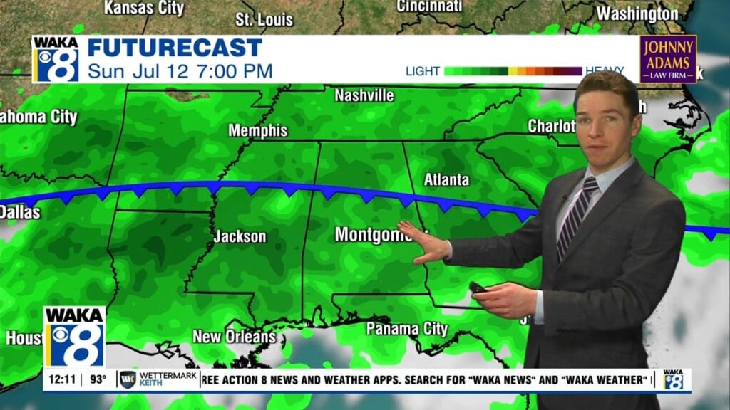
REST OF THE WEEK: Today, the upper ridge remains in place, but rain chances will increase some as a wave of energy moves along the Northern Gulf Coast. We increase our rain chances some, with more scattered showers and storms, but still these will remain widely scattered with many locations remaining dry; highs will be in the low to mid 90s. The upper ridge weakens some by tomorrow and Friday, and we expect an increase in the number of scattered showers and thunderstorms both days with lower heat levels; the high both days will be in the lower 90s.
THE ALABAMA WEEKEND: A fairly routine late August weekend of weather for Alabama; both days should feature a partly sunny sky with those randomly scattered, mainly afternoon and evening showers and storms. Chance of any one spot seeing rain will be around 50% both days; highs this weekend will be in the lower 90s.
NEXT WEEK: For now, we will stick with persistence forecast as the days remain partly sunny days with some scattered afternoon and evening showers/storms on daily basis; highs should hold in the upper 80s for much of North/Central Alabama and low 90s for South/Central Alabama.
IN THE TROPICS: There are no other active systems in the Atlantic, but there are three areas the NHC is monitoring. The next three names are Ida, Julian, and Kate.

1. A broad area of low pressure is expected to form over the western Caribbean Sea in a couple of days from a tropical wave currently located over the central Caribbean Sea. Environmental conditions are forecast to be conducive for development, and a tropical depression is likely to form late this week or this weekend while the system moves northwestward over the northwestern Caribbean Sea, near or across the Yucatan Peninsula of Mexico, and into the western Gulf of Mexico by Sunday. Formation chance through 5 days…high…70 percent.
2. A broad trough of low pressure is producing disorganized showers and thunderstorms over the central tropical Atlantic about 1000 miles northeast of the northern Leeward Islands. Only slow development of this system is expected during the next day or so due to unfavorable upper-level winds. Afterwards, environmental conditions are expected to become more conducive for development, and a tropical depression is likely to form late this week or this weekend while the system turns eastward over the central Atlantic. Formation chance through 5 days…high…70 percent.
3. A tropical wave over the far eastern tropical Atlantic located several hundred miles southwest of the Cabo Verde Islands is producing a disorganized area of showers and thunderstorms. Some development of this system is possible over the next several days while it moves west-northwestward at 10 to 15 mph over the eastern tropical Atlantic. Upper-level winds are forecast to become less conducive for development by this weekend. Formation chance through 5 days…low…30 percent.
Have a whimsical Wednesday!!!
Ryan