


ACTION 8 UPDATE: 13 tornadoes confirmed statewide
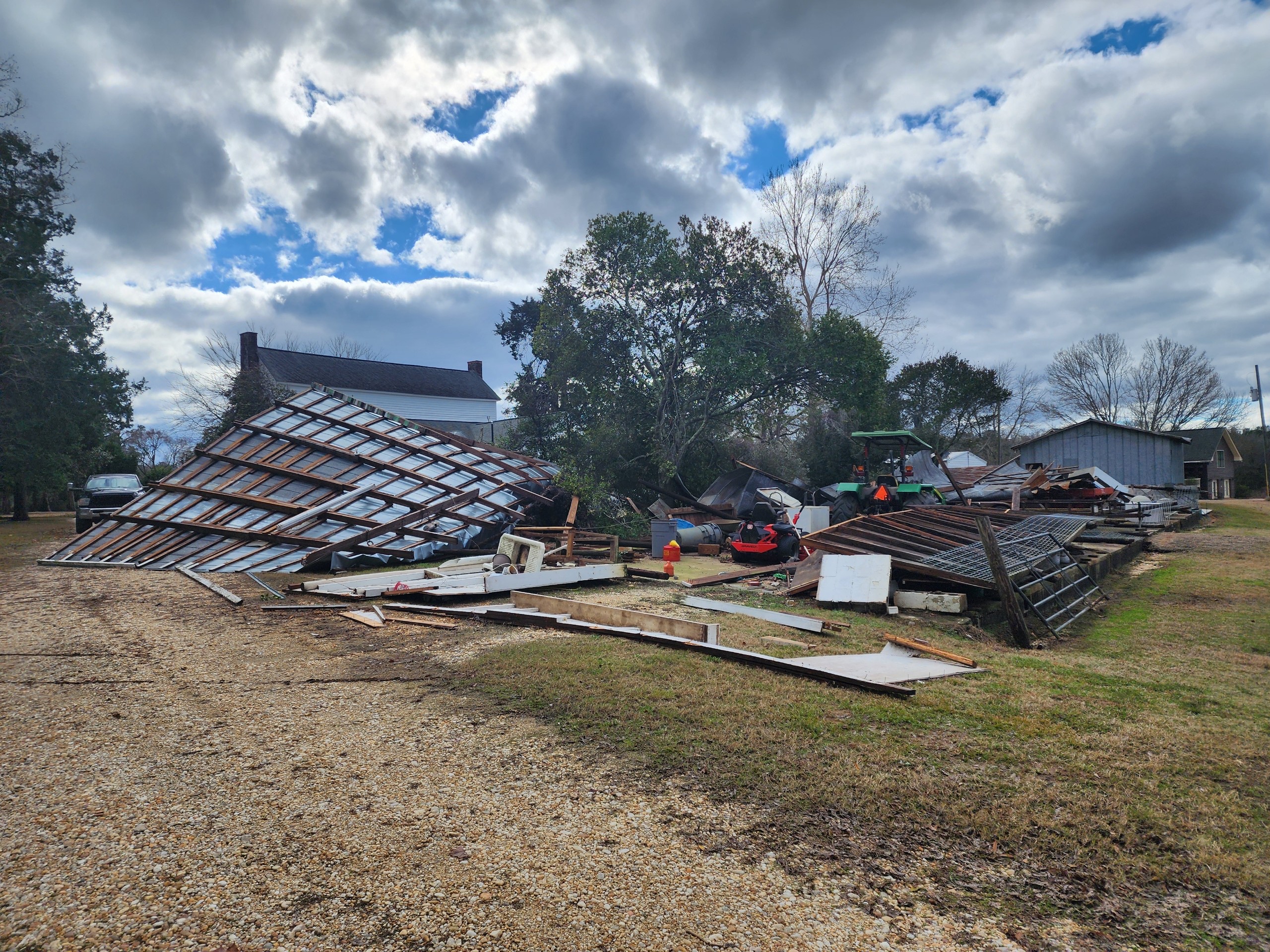
Tornado damage in Macon County, Sunday, December 29, 2024 – Photo from Macon County EMA Director Frank Lee
ACTION 8 UPDATE: The National Weather Service has confirmed that 13 tornadoes touched down statewide over the weekend, including nine in our area.
The tornadoes were part of a system that moved east into Alabama on Saturday night before pushing out of the area on Sunday morning. In our area, tornadoes were confirmed in Lowndes, Montgomery and Macon counties.
Many of the tornadoes were small, causing minor damage and were short-lived. The most significant tornado caused widespread damage in Athens, near the Limestone County Courthouse. That location is northwest of Huntsville.
Crews are still conducting surveys in other parts of the state.
Here is a list of the tornadoes in chronological order:
Tornado #1 – LAMAR COUNTY
Rating: EF-1 (winds 86-110mph)
Estimated Peak Wind: N/A
Path Length /statute/: N/A
Path Width /maximum/: N/A
Fatalities: N/A
Injuries: N/A
Start Date: 12/28/2024
Start Time: 9:27 PM CST
Start Location: N/A
Start Lat/Lon: N/A
End Date: N/A
End Time: N/A
End Location: N/A
End Lat/Lon: N/A
Survey Summary: Additional survey work is pending in Lamar County.
Tornado #2 – El Gezira Road Tornado SHELBY COUNTY
Rating: EF0
Estimated Peak Wind: 80 mph
Path Length /statute/: 1.53 miles
Path Width /maximum/: 175 yards
Fatalities: 0
Injuries: 0
Start Date: 12/29/2024
Start Time: 12:11 AM CST
Start Location: 2 WNW Harpersville / Shelby County / AL
End Date: 12/29/2024
End Time: 12:14 AM CST
End Location: 2 NW Harpersville / Shelby County / AL
Survey Summary: NWS Birmingham storm survey has determined a brief EF0 tornado impacted an area northwest of Harpersville, mainly on El Gezira Rd north of US Hwy 280. The tornado caused damage to a horse farm, impacting at least 4 structures. Varying degrees of timber damage was also observed with trees uprooted and large branches removed. The tornado caused additional damage near Prince Rd, dissipating near Highway 83.
Tornado #3 – Knight Place Road Tornado LOWNDES COUNTY
Rating: EF0
Estimated Peak Wind: 85 mph
Path Length /statute/: 1.71 miles
Path Width /maximum/: 100 yards
Fatalities: 0
Injuries: 0
Start Date: 12/29/2024
Start Time: 12:15 AM CST
Start Location: 2 ENE Clover Hill / Lowndes County / AL
End Date: 12/29/2024
End Time: 12:18 AM CST
End Location: 4 ESE Mount Willing / Lowndes County / AL
Survey Summary: A tornado began along Knight Place Rd and moved northeastward. Numerous trees were downed along or just west of the road, mainly limbs broken or uprooted trunks. A few small trees were snapped as well, along with downed power lines. A few structures sustained damage, including minor roof damage to a double wide, a single wide that was rolled over onto its roof, and a large open air shed that lost roof panels. The tree damage became less as it crossed County Road 45, but the path was extended a good bit northward into a large inaccessible area using RADAR.
Tornado #4 – Coosa Island Road Tornado ST. CLAIR COUNTY
Rating: EF0
Estimated Peak Wind: 85 mph
Path Length /statute/: 2.26 miles
Path Width /maximum/: 150 yards
Fatalities: 0
Injuries: 0
Start Date: 12/29/2024
Start Time: 12:25 AM CST
Start Location: 1 SW Coosa Island / St. Clair County / AL
End Date: 12/29/2024
End Time: 12:28 AM CST
End Location: 2 NE Coosa Island / St. Clair County / AL
Survey Summary: NWS Birmingham storm survey has determined a brief EF0 tornado impacted areas near Logan Martin Lake in far southern St. Clair County. The tornado began causing timber damage southwest of Rivercrest Dr. Numerous trees were snapped or uprooted, many fell onto homes near Shady Brook Lane. The tornado crossed the water and caused additional damaged to timber and residences on Coosa Island Rd. The tornado continued northeast causing, to a lesser degree, additional timber damage on Rabbit Branch Rd and Treasure Island Rd before dissipating.
Tornado #5 – Roberts Mill Pond Road Tornado ST. CLAIR COUNTY
Rating: EF1
Estimated Peak Wind: 0 mph
Path Length /statute/: 1.52 miles
Path Width /maximum/: 325 yards
Fatalities: 0
Injuries: 0
Start Date: 12/29/2024
Start Time: 12:30 AM CST
Start Location: 2 SE Chula Vista / St. Clair County / AL
End Date: 12/29/2024
End Time: 12:33 AM CST
End Location: 2 SSW Harrisburg / St. Clair County / AL
Survey Summary: NWS Birmingham storm survey has determined an EF1 tornado impacted and area southwest of Pell City, mainly on Roberts Mill Pond Rd. several areas of timber damage occurred, generally snapping and uprooting of hardwood trees north of Highway 27. A chicken farm sustained significant damage, with at least 5 structures impacts. Debris was thrown at least 300 yards downstream. The tornado continued northeast toward Stewart Rd causing additional, less significant timber damage, dissipating thereafter.
Tornado #6 – Hargrove Lane Tornado LOWNDES COUNTY
Rating: EF0
Estimated Peak Wind: 70 mph
Path Length /statute/: 0.63 miles
Path Width /maximum/: 75 yards
Fatalities: 0
Injuries: 0
Start Date: 12/29/2024
Start Time: 12:39 AM CST
Start Location: 4 NW Pintlala / Lowndes County / AL
End Date: 12/29/2024
End Time: 12:40 AM CST
End Location: 4 NW Pintlala / Lowndes County / AL
Survey Summary: A tornado began along County Road 26, with several cedar limbs down along the road. Numerous trees were uprooted across Hargrove Ln, and a few more trees were downed near Rolling Acres Rd.
Tornado #7 – Hope Hull Tornado MONTGOMERY COUNTY
Rating: EF1
Estimated Peak Wind: 95 mph
Path Length /statute/: 3.93 miles
Path Width /maximum/: 250 yards
Fatalities: 0
Injuries: 0
Start Date: 12/29/2024
Start Time: 12:43 AM CST
Start Location: 1 SW Hope Hull / Montgomery County / AL
End Date: 12/29/2024
End Time: 12:48 AM CST
End Location: 1 E Hyundai Motors Of Alabama / Montgomery County / AL
Survey Summary: A tornado began along Bill Johnson Pkwy and moved eastward across Folmar Pkwy and I-65. A few warehouses the intersection of Bill Joseph and Folmar sustained roof and siding damage, with several trees down as well. At the end of County Ct adjacent to I-65, two warehouses sustained major roof loss on a corner of each building along with a cinder-block wall collapse on one. Several semi trailers were flipped or tossed as well. After scattering debris across the interstate, two businesses at the intersection of U.S. 31 and Fischer Rd sustained roof and structural damage, with several more semi trailer behind the buildings being flipped or moved. Just south of this location, Hooper Academy had mostly minor damage to the building and surrounding grounds which was not directly related to the tornado. Continuing east-northeast,
several trees were uprooted north of Lagos Ln as the tornado tracked northeastward toward Hyundai Blvd. A newly constructed
greenhouse-type building south of the main Hyundai facility had much of the covering ripped off. A house and shed at Hyundai Blvd had roof loss, and across the road a small metal building at the southeast corner of the Hyundai campus had roofing removed and blown across a railroad into a tree line. The tornado appeared to dissipate at this point, just before reaching U.S. 331.
Tornado #8 – Mt. Zion Road Tornado MONTGOMERY COUNTY
Rating: EF1
Estimated Peak Wind: 100 mph
Path Length /statute/: 10.01 miles
Path Width /maximum/: 500 yards
Fatalities: 0
Injuries: 0
Start Date: 12/29/2024
Start Time: 12:53 AM CST
Start Location: 3 E Sprague / Montgomery County / AL
End Date: 12/29/2024
End Time: 01:05 AM CST
End Location: 2 NE Carters Hill / Montgomery County / AL
Survey Summary: A tornado began along Hobbie Rd and Hillabee Rd with a few uprooted trees and broken limbs. Tree damage gradually became more concentrated as the tornado moved northeastward, with a home south of Ridgeland Farms Rd having the top of a pine tree fall on it. Several trees were uprooted across wooded areas before the tornado arrived at Mt. Zion Rd, where numerous pine trees were snapped or uprooted, one of which fell into the corner of a double wide. Significant splatter was observed on the east facing side of the double wide. A couple sheds nearby sustained damage as well. Numerous trees were uprooted northeastward across wooded areas and pastures to Woodley Rd and further to U.S. 231, where the BBQ Hill business sustained roof damage and had numerous pine trees snapped or uprooted on the premises. More trees were damaged and an outbuilding was damaged along Old Carter Hill Rd as the tornado dissipated.
Tornado #9 – Cecil Tornado MONTGOMERY COUNTY
Rating: EF0
Estimated Peak Wind: 80 mph
Path Length /statute/: 2.50 miles
Path Width /maximum/: 100 yards
Fatalities: 0
Injuries: 0
Start Date: 12/29/2024
Start Time: 01:11 AM CST
Start Location: 2 SW Cecil / Montgomery County / AL
End Date: 12/29/2024
End Time: 01:13 AM CST
End Location: 1 SE Cecil / Montgomery County / AL
Survey Summary: A tornado was confirmed using aerial and ground surveys. Convergent tree damage was noted in a wooded area west-southwest of Split Bark Dr. Several small trees were snapped or uprooted along Hickory Hollow Cove and a garage sustain partial roof loss. Further east along Cecil Station Rd, numerous trees were uprooted and tree limbs were snapped. A concentrated area of tree damage continued across Flowers Rd and Vaughn Rd, and the tornado appeared to dissipate just east of Vaughn Rd and Pharr Rd.
Tornado #10 – Jackson Road Tornado MACON COUNTY
Rating: EF0
Estimated Peak Wind: 75 mph
Path Length /statute/: 1.86 miles
Path Width /maximum/: 175 yards
Fatalities: 0
Injuries: 0
Start Date: 12/29/2024
Start Time: 01:18 AM CST
Start Location: 1 SE Tysonville / Macon County / AL
End Date: 12/29/2024
End Time: 01:21 AM CST
End Location: 1 SSW Victoryland / Macon County / AL
Survey Summary: A tornado began south of U.S. 80 in a wooded area and moved northeast. Several trees and tree limbs were downed across Jackson Rd. Further northeast, numerous limbs were snapped out of trees along a driveway on the north side of U.S. 80. No other damage was found past this location. A Tornado Debris Signature was observed on KMXX RADAR.
Tornado #11 – Shorter Tornado MACON COUNTY
Rating: EF0
Estimated Peak Wind: 75 mph
Path Length /statute/: 5.55 miles
Path Width /maximum/: 200 yards
Fatalities: 0
Injuries: 0
Start Date: 12/29/2024
Start Time: 01:18 AM CST
Start Location: 2 S Shorter / Macon County / AL
End Date: 12/29/2024
End Time: 01:27 AM CST
End Location: 2 ESE Milstead / Macon County / AL
Survey Summary: A tornado began over an inaccessible area north of County Road 2 and south of Old Federal Rd. Several trees were uprooted or limbs were snapped around a couple homes and a church as the tornado crossed Old Federal Rd and U.S. 80. More trees were uprooted as the tornado crossed Redland Rd and Cross Keys Rd, where the most substantial area of tree damage occurred just north of Deborah Cannon Wolfe School. The damage extent decreased substantially crossing County Road 30, with small trees and tree limbs downed. A few more tree limbs were downed along County Road 9 as the tornado track ended.
Tornado #12 – County Road 8 Tornado MACON COUNTY
Rating: EF0
Estimated Peak Wind: 85 mph
Path Length /statute/: 2.17 miles
Path Width /maximum/: 75 yards
Fatalities: 0
Injuries: 0
Start Date: 12/29/2024
Start Time: 01:30 AM CST
Start Location: 3 SSE Reeves Airport / Macon County / AL
End Date: 12/29/2024
End Time: 01:32 AM CST
End Location: 2 WNW Franklin / Macon County / AL
Survey Summary: A tornado began near the confluence of Chewacla Creek and the Tallapoosa River, moving due east just north of County Road 8. Several trees were snapped or uprooted in a wooded area adjacent to the railroad. A Tornado Debris Signature was detected by KMXX RADAR.
Tornado #13 – County Road 56 Tornado MACON COUNTY
Rating: EF0
Estimated Peak Wind: 60 mph
Path Length /statute/: 0.76 miles
Path Width /maximum/: 50 yards
Fatalities: 0
Injuries: 0
Start Date: 12/29/2024
Start Time: 01:31 AM CST
Start Location: 2 NNE Franklin / Macon County / AL
End Date: 12/29/2024
End Time: 01:32 AM CST
End Location: 3 N Franklin / Macon County / AL
Survey Summary: A weak tornado moved northward across County Road 56, just southwest of Sharpe Field. Only a few small trees and tree limbs were downed. A Tornado Debris Signature was detected by KMXX RADAR.
Stay with Action 8 News for updates on tornado reports from the National Weather Service.


