Wet Wednesday, Warm Weather Ahead
FOR WEDNESDAY: This morning we are dealing with lingering showers, but those should end early this afternoon. The clouds look to hang around much of the day, but some peeks of afternoon sunshine will be possible. Highs today climb back into the upper 60s and lower 70s. Tonight, area of fog will develop and lows will be in the mid 50s.
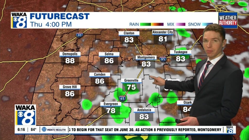
DRY AND VERY MILD: To end the work week, we will be in between systems. Thursday will be mainly sunny and quite warm for February, as highs climb into the upper 70s. Friday, expect sunny conditions with temperatures in the lower 80s. Also on Friday, to our north, a trough will cause a low pressure system to track towards the Great Lakes and we are going to see a cold front towards Alabama. Ahead of the front severe weather is expected, but to the north of Alabama, across the Ohio Valley. With the better dynamics to the north, and very little moisture return expected, severe weather will not be an issue for Alabama. However, overnight Friday as the front moves across the state, we are going to see some rain and storms pass through the state. As the front exits rapidly early Saturday, cooler weather arrives for the weekend.
THE ALABAMA WEEKEND: Behind the cold front, expect dry and cooler weather. Both Saturday and Sunday, very nice weather is expected, and the sky will be mostly sunny. Afternoon highs will be in the mid and upper 60s for most places. Sunday morning will be pretty chilly with a low in the 30s.
FINISHING OUT FEBRUARY: Hard to believe another month of 2017 is coming to an end early next week. The week looks mild and rather unsettled, but there is very low confidence in specific details now with little model consistency or agreement. A few periods of showers and storms seem likely; rain is possible as early as Tuesday. Remains to be seen if we will have severe weather issues or not, but remember the spring tornado season kicks off next week.
Have a great day!
Ryan