Warm, Active Week of Weather
THE FINAL WEEK OF MARCH: The month of March will go out like a lion as we are going to see a very active weather pattern that will provide multiple rounds of thunderstorms. We remain in an active, moist southwesterly flow that will cause several low pressure systems to eject out of the Plains and will bring the threat of storms with them to the state.
MONDAY/TUESDAY: A low pressure will track from the Red River Valley up to the St. Louis area today. This will keep Alabama in the warm sector of the storm system, and we are going to see another round of storms move through Alabama this afternoon/evening, and some of these could be strong. The SPC maintains portions of Central Alabama highlighted in a “marginal risk” for severe storms, with the “slight risk” for area of North/Central Alabama.

The main threat for severe weather looks to be northwest of the state, but some strong and possibly severe storms will be possible with the favorable upper level dynamics and surface based CAPE values of 1000-2000 j/kg. Damaging wind gusts and hail are possible The main activity should impact Alabama late today and tonight. We are likely to start our Tuesday off with some lingering showers/storms, but should see a clearing sky by the afternoon. Both these days will feature highs in the lower 80s.
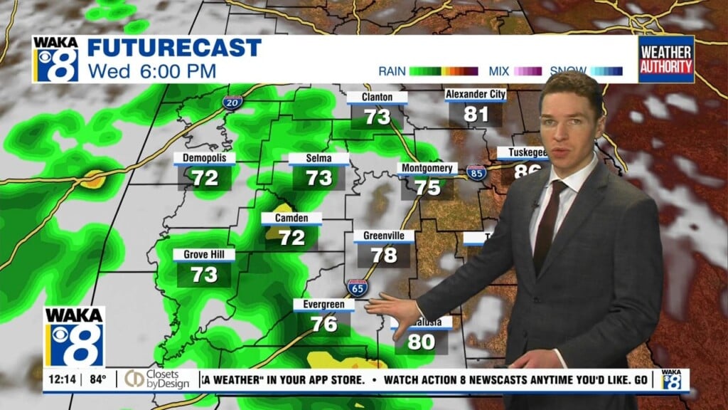
WEDNESDAY: Still looking at a midweek break in the action as we are going to be between systems. This day will feature plenty of sun and very warm temperatures, highs in the upper 80s are expected.
THURSDAY/FRIDAY: The next low pressure heads our way out of the southern Plains and that means showers and storms for Alabama, and yes, another round of strong to severe storms will be possible. In their day 4 outlook, which is for Thursday, the SPC does have much of Alabama highlighted in a threat for severe weather. Lets get through today’s threat before we start focusing on this next round of storms, but just note, severe weather will likely be possible Thursday afternoon and evening. Highs both these days will be in the lower 80s as well and it looks though Friday afternoon will be very nice as dry air moves into the state.
WEEKEND SNEAK PEEK: As of now, the Friday system will be out of here and an area of high pressure will settle into the Southeast. Both Saturday and Sunday look to feature mainly sunny and dry conditions; highs in the upper 70s, lows in the upper 50s.
Have a marvelous Monday!
Ryan